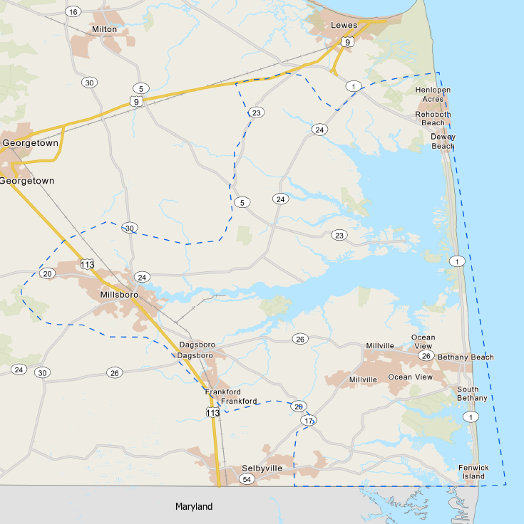
The Delaware Inland Bays and Delaware Bay Coast, Coastal Storm Risk Management Feasibility Study has resumed following the procurement of additional federal and non-federal funding.
The USACE and DNREC team assessed existing vulnerabilities from coastal storms within the authorized study area, as well as an array of flood risk management measures. Given the technical complexities of the flood problems, geographic scope, and environmental considerations, USACE and DNREC decided to pause the study and re-evaluate the best path forward to address coastal storm risk in July of 2023. As of May 2024, both study partners have identified additional funding to resume the feasibility study. The goal of this re-start of the study is to revisit the study scope and perform detailed cost estimating. The new scope would be the basis for a formal request of additional funding opportunities into the future. The focus areas will be Delaware’s Inland Bays. . USACE and DNREC may continue to pursue joint funding opportunities and work under other authorities and programs in order to increase flooding protection for residents and businesses.
Additional Background:
- During iterative scoping of the study in late Spring 2023, USACE’s cost estimate increased significantly beyond the initial $2 million budget. This is mainly due to the complexities associated with analyzing structural measures (i.e., physical barriers designed to protect specific geographic areas from flooding) in the study area.
- The work to date on the Delaware Inland Bays and Delaware Bay Coast study included valuable screenings of flood vulnerability, critical infrastructure, public and private infrastructure, and evaluations of environmental justice and equity. This preliminary work may be applied to other authorities/programs at the federal and state level.
- The study was paused in July 2023 pending the need of additional funding to achieve its identified scope.
- The study resumed in May 2024 with the procurement of additional cost shared funding from the USACE and DNREC.
The USACE study process involves identifying problems under current and future conditions; gathering data; identifying and evaluating alternatives that can address the problems; and ultimately recommending a plan. Alternatives are assessed to determine if they are feasible from an engineering standpoint, a cost-justification standpoint, and environmental standpoint.
USACE will conduct the study objectively, consider all input, and analyze alternatives with sound science. Any proposed changes must be economically justified, environmentally acceptable, and technically sound. It is worth noting that some USACE studies result in a no-project recommendation; some result in a recommended plan but don’t get authorized by Congress; and some studies/recommendations get authorized by Congress but are not funded and do not get built or implemented.
The U.S. Army Corps of Engineers (USACE; includes team members from both the Philadelphia District and the Baltimore District) is managing the overall study. The Delaware Department of Natural Resources & Environmental Control (DNREC) serves as the non-federal sponsor for the study. The total $2 million study funding comes from a 50/50 cost share between USACE and DNREC. This funding covers the cost of the study, not the implementation of the study recommended solutions. Funding for the implementation of the study-recommended solutions is not limited to state or federal funding sources.

Though the authorized study area initially included Inland Bays and Delaware Bay shorelines, the study scope needed to be refined. The data-driven down-scoping considered existing or ongoing coastal flood mitigation studies, population and critical infrastructure at risk to coastal flooding, and equity opportunity areas, in addition to other technical data. The study area was refined/down-scoped to align with the budget, time considerations, and other factors.
The project team have determined that the focus area of the study will be the Delaware Inland Bays area, including watersheds around Rehoboth Bay, Indian River Bay, and Little Assawoman Bay. The study will focus on developing solutions to coastal storm flooding and is not necessarily going to produce solutions to sunny-day (nuisance) flooding or rainfall drainage issues. Sea level rise will be incorporated into the study in order to plan for a more resilient future.
The Inland Bays area was selected for the following reasons:
- The high number of critical structures that are essential for everyday life within the 1-percent-annual-chance (100-year) floodplain (e.g. police stations, fire stations, schools, daycare centers, hospitals and other healthcare centers, roadways, evacuation routes, fueling stations, etc.).
- The high number of residential and commercial structures within the 1-percent-annual-chance (100-year) floodplain.
- The number of underserved communities within the 1-percent-annual-chance (100-year) floodplain. Underserved communities are communities that include a high proportion of residents in poverty and a high proportion of Black or Hispanic or Asian or American Indian residents.
- The high frequency of flooding events affecting the Inland Bays area.
- The remaining uncertainty about local coastal flood issues and potential solutions.
- The low number of coastal models necessary to analyze this study area.