SOURCES AND INSTANCES OF FLOODING
The Delaware River has a long history of flooding. The river's floodplain, as well as those of its tributaries, has been subject to both local and widespread damage. Watersheds adjacent to the Delaware River, like many others throughout the nation, have been increasingly affected by flooding because people live, work, travel, and recreate in the floodplains, and because their land use activities have increased the runoff from watersheds and changed the hydraulics of the floodplain itself.
Floods from a river overflowing its bank are known as "fluvial" floods and are usually caused by storms that traverse the basin. These storms are either of tropical origin (hurricanes) or extra-tropical, such as thunderstorms and nor'easters. Storms occur on their own and in combination, with the most intense precipitation resulting from a combination of both types. Movement of warm, moist air into contact with surrounding air of lower temperature produces the violent thunderstorms and intense precipitation of the summer months and the nor'easters of the cool months. The latter are of coastal origin and are accompanied by severe winds and possible flood-producing precipitation. Floods can also be caused by combinations of storms, snowmelt, ice jams and tidal action.
The section of the Delaware River below Burlington, New Jersey, is tidal and significantly wider than the sections further north, and less prone to flooding. When floods do occur in this section, they are caused by several factors, acting alone or in combination: flows from the upper river, high spring tides resulting from tidal fluctuations, and wind tides produced by hurricanes or storm action.
1955 FLOOD OF RECORD AND 2004-2006 FLOODS
Record flooding on the Delaware River occurred in August 1955, in the aftermath of two separate hurricanes traversing the area within less than a week. First, Hurricane Connie produced 10 inches of rain in 48 hours, putting the Delaware and surrounding rivers at flood stage. Hurricane Diane, which remains the wettest tropical cyclone to have hit the northeastern US, added another 10 inches of rain less than a week later. Extensive property damage and loss of life ensued. The National Weather Service has estimated repetition of this record flood event would cause $2.8 billion in damages in the Delaware River Basin in today's dollars. Although flooding of this scope and magnitude is rare, damage and loss of life have occurred from more localized flooding during lesser events.
Most recently, the remnants of Tropical Storm Allison caused $35 million in damages and resulted in seven deaths in Bucks and Montgomery Counties, PA in June of 2001. From Warren County downstream to Trenton, flooding in September of 2004, April 2005, and June 2006 caused property damage and required evacuations. These three floods caused a total of close to $745 million of damage in the states of New York, New Jersey and Pennsylvania.
FLOOD STUDIES
In 1962, after the 1955 flood of record, Congress authorized the construction of the Tocks Island Dam on the main stem of the Delaware River, just north of the Delaware Water Gap. The dam was designed to control water levels for hydroelectric power generation, reduce downstream flooding, and create a 37-mile long reservoir in the center of the newly created Delaware Water Gap National Recreation Area. Over a period of many years, the project met with numerous major impediments, including local opposition, geologic issues, and financial limits. In 1975, the project was indefinitely delayed; in 1978, the project area became part of the National Wild and Scenic River system; in 1992, the project was re-reviewed and tabled for another 10 years; and in 2002 Congress officially deauthorized the Tocks Island Dam Project.
In August 1984, the Corps of Engineers released the Delaware River Basin Study Survey Report, which provided an analysis of the economic justification of nonstructural flood risk management in 58 communities along the main stem Delaware River. Actions in twelve communities were found to be economically justified. However, no further Federal action was recommended because the study found that flood risk management measures would only benefit a small portion of the floodplain and there was only one potential local sponsor. As will be further discussed below, the Delaware River Basin Comprehensive Study - Interim Feasibility Study for New Jersey is now evaluating structural, nonstructural, and ecosystem restoration measures for targeted communities in the river’s floodplain. The study is a joint effort of the US Army Corps of Engineers-Philadelphia District and the New Jersey Department of Environmental Protection.
BASINWIDE PLANNING
In response to the floods of 2004 - 2006, and the history of flooding in the watershed, the multi-state Delaware River Basin Commission (DRBC), the Corps of Engineers, and local governments are working to address the issue of flooding along the river. The DRBC prepared A Multi-Jurisdictional Flood Mitigation Plan for Municipalities in the Non-tidal, New Jersey Section of the Delaware River Basin to identify regional, countywide, and municipal mitigation actions that could reduce future flood losses. The DRBC plan demonstrates local coordination and commitment and serves as an important step toward creating an All Hazards Mitigation Plan, which will allow the local municipalities to become eligible for future mitigation funds from FEMA. The DRBC plan contains Basin-wide flood risk management strategies and priorities, a listing of local flood risk management strategies, and an analysis of flood insurance claims. The plan contains over 160 flood risk management actions developed by individual municipalities and counties, and identifies the following communities as having high vulnerability to flooding:
Warren County: Belvidere, Blairstown Township, Harmony Township, Phillipsburg, and Pohatcong Township.
- Mercer County: Trenton City
- Hunterdon County: Frenchtown Borough, Kingwood Township, Stockton Borough
The Task Force that prepared the DRBC plan organized its recommendations into six priority management areas:
Reservoir operations: Evaluation of reservoir spill and discharge risk management programs along with development of a flood analysis model to evaluate alternative reservoir operating plans and to assess the downstream effect of reservoir voids of different magnitudes. These recommendations call for releases that would reduce the likelihood and volume of spills from some basin reservoirs during storm events to help lessen flooding.
Structural and non-structural solutions: Prioritization and greater funding of nonstructural measures such as acquisition of property and elevation and/or floodproofing of structures within the floodplain. An evaluation of flood risk management measures throughout the basin by the Corps of Engineers was recommended to include an analysis of the ecological, economic, long-term operation and maintenance, and social costs and benefits of all flood flood risk management options.
Stormwater management: Minimization of stormwater runoff from new development and reducing runoff from existing development through implementation of watershed stormwater management plans, long-term maintenance of stormwater infrastructure (including detention ponds, inlets, catch basins, outfalls, and other devices), the use of nonstructural stormwater management options, expanded incentives for achieving objectives, stronger enforcement of regulations, and the development of stream restoration and debris removal guidelines.
Floodplain mapping: Because the Delaware River is an interstate waterway, coordination is needed for development of a seamless floodplain map that is consistent throughout the Basin. The Task Force called upon the states to coordinate flood study and mapping updates, incorporate existing and planned development and residual risk zones into new maps, and redefine and re-map the floodway along the main stem and its tributaries.
Floodplain regulations: Currently, the regulations applicable to floodplain areas in the Delaware Basin vary widely. The Task Force called for evaluation of existing regulations and development of uniform regulations. In addition, it recommended that a coordinated education, outreach and training program about floodplain risk management and regulation be undertaken, that a flood hazard disclosure requirement be imposed, that a repetitive loss strategy be adopted and that riparian zones be defined in accordance with uniform standards basinwide.
Flood warning: The Task Force recommended that development of an advanced basinwide flood warning system proceed in a coordinated fashion. The existing system is comprised of flow gages, flash flood and flood forecasting, and education and outreach components. The Task Force recommended a range of actions, including evaluation of the river gage network and its forecast points, that gages be flood hardened (i.e., able to withstand larger flood events), that flash flood forecasting be improved, flood inundation maps be developed, that up-to-date Dam Emergency Action Plans be maintained, that a coordinated flood education and outreach program be developed and that a comprehensive program be undertaken to address coastal flooding.
Specific actions reflecting these priority areas are described below. Additional information on such actions can be found here.
SPECIFIC STUDIES AND ACTIONS
Reservoir operations: The development of the Flexible Flow Management Program for the New York City Delaware Basin Reservoirs creates a new tool for addressing flood risk.The primary purpose of the Cannonsville, Pepacton and Neversink Reservoirs (known as the City Delaware Basin Reservoirs) is to provide safe and reliable fresh water to over 17 million people. The FFMP, agreed to in 2007 by the states of Delaware, New Jersey, Pennsylvania, and New York, provides a comprehensive framework for addressing additional flow management objectives including "to assist in mitigating the impacts of flooding", and a number of environmental objectives such as protection of ecological health and repelling salinity. To mitigate flooding, the FFMP allows for the advance drawdown (or discharge) of a specific volume from the reservoirs based on an estimation of water volume in the basin snowpack. The resulting "void" allows for retention of anticipated runoff in the reservoir and a reduction in downstream flows and river elevations. However, historic data indicate that major flooding on the main stream Delaware River occurred before the City Reservoirs were built and thus voids in the reservoir are not intended for, nor capable of, eliminating downstream flooding.
Floodplain mapping is being updated for the New Jersey counties along the Delaware through the joint activities of FEMA, the Corps of Engineers, the United States Geological Survey (USGS), and the New Jersey Department of Environmental Protection (NJDEP). Activities by the USGS include updating flood magnitude and frequency information, collecting high water marks, and developing equations for estimating flood flows. In addition, the USGS published the report Flood Magnitude and Frequency of the Delaware River in New Jersey, New York, and Pennsylvania (USGS, 2008). This report determined the magnitudes (known as "recurrence intervals") for the 2004-2006 floods. This information was then used by FEMA to update its Flood Insurance Studies, which serve as the basis for floodplain mapping. When completed, the new flood maps will be available on-line at the FEMA Map Service Center.
Floodplain regulations: New Jersey adopted the Updated Flood Hazard Area Control Act Rules (N.J.A.C. 7:13) in November 2007, which incorporate more stringent standards for development in flood hazard areas and riparian zones adjacent to surface waters throughout the state. To minimize the impacts of development on flooding, a 0% net-fill requirement now applies to all non-tidal flood hazard areas in the state. The law requires floor elevations and roadway surfaces to be set at least one foot above the State's Flood Hazard Area Design Flood (NJFHADF), elevation (the elevation correlating to 125% of the 100-year flow rate reported by FEMA) to reduce flood risks to buildings and public roadways. In addition, the law expands riparian zones to 50, 150, or 300 feet in width along each side of surface waters throughout the state. The riparian zone width depends on the environmental resources being protected, with the most protective 300-ft zone applicable to waters designated as Category One and certain upstream tributaries.
Flood warning capacity in the Delaware River Basin has been increased by the efforts of the United States Geological Survey (USGS), the National Weather Service's (NWS) Advanced Hydrologic Prediction Service (AHPS), and the Corps of Engineers. USGS has upgraded its gaging stations and communication networks to provide detailed information on river temperature, discharge volumes, height and projected water levels. USGS has upgraded its precipitation and stream gage network in the Delaware River Basin, hardened selected gages to protect them from damage during high flows. These efforts have enhanced USGS' ability to provide information on river conditions for both Pennsylvania and New Jersey. NJDEP completed major gage repairs at the Delaware River in Montague, Riegelsville, and Trenton. In addition, new gages (radar stage and tipping buckets) have been installed in Stockton and Lambertville.
USGS operates the WaterAlert system which sends e-mail or text messages to subscribers whenever a user-defined condition (e.g., discharge volumes) is met. NWS' Advanced Hydrologic Prediction Service (AHPS) is a web-based system that provides the magnitude and uncertainty of occurrence of floods, in advance. The AHPS provides stream gage data observations, river forecasts (within 48 hours), precipitation data, and flood stage warnings. The Corps of Engineers prepared detailed flood inundation mapping of the Delaware River Basin and provided it to NWS for use in the AHPS system. This mapping correlates to flood forecast points.
Links to the NWS, AHPS, and USGS sites, the DRBC's automated e-mail flood warning system, and reservoir information are provided by the DRBC's "Flood Information Web" site.
Education and outreach initiatives include the establishment of a resource center by the organization Focus on Floods and a flood museum as a project of the Nurture Nature Foundation, formation of an Association of State Floodplain Managers chapter to educate the public on sound floodplain management, and funding for flood warning education and outreach as part of the enhancement of the Delaware River Basin’s flood warning system. Both the New Jersey (NJAFM) and New York (NYSFSMA) chapters of the Association of State Floodplain Managers, are active in addressing and educating sound floodplain management, as is the Pennsylvania Association of Floodplain Managers.
BASINWIDE STUDIES
Enhancing Multi-jurisdictional Use and Management of Water Resources for the Delaware River Basin, NY, NJ, PA, and DE. This study identified flood prone areas within the Delaware Basin using information from Federal Emergency Management Agency (FEMA) claims to develop a potential solution matrix and apply it to the damaged areas. The effort included conducting a structure inventory in the damaged areas and updated flood frequency data with information from the recent floods.
Delaware River Basin Comprehensive Study - Interim Feasibility Study for New Jersey. This joint study by the Corps of Engineers and the NJ Department of Environmental Protection evaluates potential solutions to frequent flooding problems and related environmental degradation within the Delaware River Basin. NJDEP has signed a feasibility cost-sharing agreement with the Corps and is acting as the local sponsor for the study. The study area is composed of communities in Warren, Hunterdon, and Mercer Counties with histories of flooding, plus the Gloucester County communities of Greenwich and Logan Townships, in which is located a non-Corps levee along the Delaware River.
This study has gathered information from residents and local officials, reviewed previous reports, conducted site visits and compiled a detailed floodplain building inventory, prepared a computer model of expected flood damages under a range of conditions, and is now evaluating possible flood risk management options in selected flood-prone New Jersey communities along the Delaware River.
An array of potential solutions is available for consideration to address flooding issues. Most of these options were addressed by the Corps in the August 1984 Delaware River Basin Study Survey Report. The current study revisits the previously identified options, using updated information, including surveys, mapping and modeling in the assessment, as well as considering new or modified alternatives.
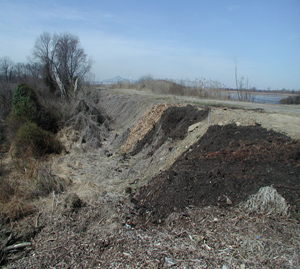
In the southernmost part of the study area, in the communities of Greenwich and Logan Townships, is a 4.5 mile long levee that runs along the Delaware River. Known as the Repaupo (or Gibbstown) Levee, it was constructed in the late 1600s to reclaim land for agricultural purposes. Since then, its original purpose has become obsolete and the original owner, the Repaupo Meadow Company, is now defunct. At least three commercial entities and a municipality all own portions of the levee, with other portions’ ownership in question.
In 1962, the levee breached and the Corps provided emergency repairs. The NRCS also replaced the White Sluice Race floodgate (part of the Repaupo Levee) in the same year. A 1967 Corps Reconnaissance Study estimated the level of protection provided by the levee at about a 7.14% ACE (14-year) event, and proposed raising the levee to provide a 1% Annual Chance of Exceedance (ACE) (100-year) level of protection. In 1969, the sponsor was unable to provide the necessary construction funds. In 1973, the sponsor requested the study be reactivated but was unable to secure real estate easements and the study was again terminated. In 2000, the Corps provided emergency repairs to the Repaupo floodgate, including placement of sandbags and plastic sheeting. In addition, field inspections have been performed over the years. In 2005, the Corps provided further emergency repairs to the Repaupo floodgate. The Corps’ 2007 Inspection of Local Flood Damage Reduction Project, Gibbstown, New Jersey, (November 2007) conducted an inspection for eligibility of the levee under Public Law 84-99. The project was rated Unacceptable due to lack of a public sponsor for the entire levee.
Most recently, the NJDEP Bureau of Dam Safety & Flood Control provided a 75% matching flood control grant to the Gloucester County Improvement Authority to repair the Repaupo floodgate. The repair project has been estimated to cost approximately $3 million. In July 2009, Phase I of the reconstruction of the Levee and Floodgate was completed. Phase I consisted of floodgate repairs and raising a section of levee over 900 feet long.
However, sections of the overall structure have fallen into various states of disrepair. The degradation of the structure is largely due to the material make-up of its foundation. US Army Corps of Engineers criteria for a levee suitable for flood risk management typically require a foundation of impervious material, such as clay core or shell. The levee's foundation consists of soft organic soils and loose sands imbedded with sandy gravel.
These materials are prone to settlement and seepage, which can lead to levee failure through overtopping and cracking as well as through flooding or piping of levee materials, respectively. These materials, in addition to a lack of regular maintenance, have led to the conclusion that the levee, as is, does not provide flood risk management to Corps standards.
The Delaware River Basin Comprehensive Study - Interim Feasibility Study for New Jersey is evaluating potential structural, nonstructural, and ecosystem restoration measures to provide flood risk management in Greenwich and Logan Townships. Measures under review include nonstructural retrofit, construction of a new line of protection levee, and increased flows and salinity in marsh and wetland areas to restore ecological function and habitat value.