Note:
This study is no longer active, but the content will remain online for information purposes.
Background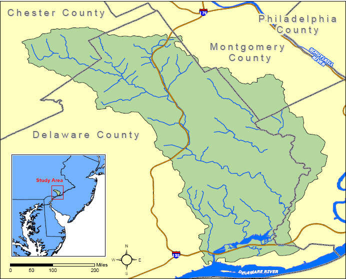
The Darby-Cobbs watershed discharges to the Delaware River through the wetlands of the John Heinz National Wildlife Refuge at Tinicum. The watershed encompasses approximately 80 square miles of southeastern Pennsylvania and flows through 31 municipalities in parts of Chester, Delaware, Montgomery, and Philadelphia Counties. It can be divided into three subwatersheds: Cobbs Creek, Darby Creek, and Tinicum. Most of the Darby-Cobbs watershed is highly urbanized and as much as 66 percent of the surfaces are impervious.
The Darby-Cobbs Watershed Sediment Assessment has two objectives. The first objective is to perform a watershed-scale assessment to develop a map of potential sediment imbalances and identify effective design or remediation needs. The second objective of the study is to use this information to develop a framework for the restoration of urban watersheds. This framework will be applicable nationwide because watersheds plagued by urban sprawl, degraded habitat, recurrent flooding, and several stakeholders with conflicting interests are not unique to the Darby-Cobbs watershed or the Philadelphia District. Although many of the problems in urban watersheds are a result of imbalances in the sediment equilibrium, sediment transport is rarely assessed on a watershed scale. This demonstration project provides an opportunity for the Corps to apply unbiased technical expertise to practical issues. The products will improve the planning and design of ongoing and future projects and will benefit the Corps and many other agencies and stakeholders.
Issue:
The streams and creeks within the watershed have been a consistent problem in terms of flooding, stormwater runoff, streambank erosion, ecological degradation, and aesthetics. The Philadelphia District began studying this watershed in 1970 and has initiated 20 official studies over the past 35 years. Only one of these projects, a small gabion streambank reinforcement project, was constructed. Most of these studies were initiated by individual municipalities and were terminated because it was not economically feasible to armor a section of stream within a small study area.
Studies from a municipality-based scale have not been effective. An unbiased watershed-scale assessment is needed. This assessment will take sediment transport into account and determine the specific causes of problems. This will be done by analyzing project alternatives using a Sediment Impact Assessment Model (SIAM) and other models to identify effective design and remediation needs. While sponsorship and political issues are being sorted out, this assessment will identify areas for projects and those projects could be co-sponsored by those municipalities.
Expected Products:
The end product of this assessment will be a comprehensive watershed plan that will recommend appropriate methods for immediate and long-term solutions. It will address bank erosion/sediment deposition, dam/impediment removal, greenways, riparian buffers, and sediment input into the Delaware Estuary. It will include advance designs for more immediate objectives.
The plan will be based on the results of a Sediment Impact Assessment Model (SIAM). Data will be collected for model input. The model will also incorporate historic data. Products to date include: coordination with stakeholders, compilation of all reports on the watershed, creation of report database, digitizing old reports, creation of interactive watershed map for website (in process- projected completion February 2009), pamphlet on urban watersheds.
Potential Users:
The Corps of Engineers, counties, boroughs and municipalities, environmental resource agencies, and watershed groups.
Projected Benefits:
Products will expedite Feasibility Phase of future studies, improve planning & design of ongoing & future projects, and allows a non-traditional assessment to be conducted while sponsorship & political issues are being sorted out. This is an opportunity for USACE to apply unbiased technical expertise to practical issues. This project provides a framework applicable to urban watersheds nationwide